> > while the most obvious places to look for remains of ancient civilization are upon exposed land [
http://en.wikipedia.org/wiki/Giza_pyramid_complex -
http://en.wikipedia.org/wiki/Carnac_stones -
http://en.wikipedia.org/wiki/Stonehenge -
http://en.wikipedia.org/wiki/Teotihuacan -
http://en.wikipedia.org/wiki/Maya_architecture -
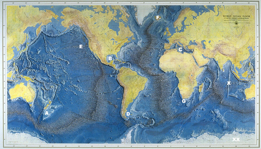
http://en.wikipedia.org/wiki/Ley_lines] - there has been roughly 50+ ice ages on earth where large quantities of water were trapped up in glacial ice, leaving large swaths of presently submerged land exposed - the most obvious zones to look for ancient civilization is on raised portions of submerged land below sea level and/or in ancient valleys - for instance;
A) the new zealand and/or challenger plateau;
B) the gulf of mexico (buried in silt just off the coast of florida; pyramids the size of the
giza plateau pyramid complex in north africa have been found with imaging technology);
C) the mediterranean basin - the malta plateau in particular (much like
san francisco bay; the entire mediterranean basin was once an ancient valley);
D) the falkland islands and adjacent submerged coastal zones;
E) ancient beaches have been found on the once-exposed mendocino ridge;
F) semi-annual 40,000 year
pole shifts would place iceland at varying latitudes and/or longitudes during various earth epochs;
G) off the coast of south africa;
X) ninety-east ridge looks almost artificial, but was actually caused by northern movement of the
indian subcontinent, which raised the
himalayas;
XX) the piri ries map appears to depict antarctica without ice, and some believe -- due to pesky semi-annual pole shifts -- this is the possible location of the legendary
atlantis...
MARIE THARP was a geologist and oceanographic cartographer who, along with her colleague Bruce Heezen, co-discovered the Mid-Oceanic Ridge, a line of undersea mountains that runs through Earth's oceans, and mapped the features of the entire ocean floor - Heezen and Tharp began working together to map the topography of the ocean floor in 1947 at the Lamont Geological Laboratory (now the Lamont-Doherty Earth Observatory) at Columbia University in New York City. For the first 18 years of their collaboration, Heezen collected data aboard the Observatory's ship, the Vema, and Tharp drew the maps from that data. (Since traditionally, women were not allowed on board ships at that time, Tharp did not accompany Heezen on a data-collecting expedition until 1965.) Tharp also used data collected from the Woods Hole Oceanographic Institution's research ship, the Atlantis, and seismographic data from undersea earthquakes. Their work represented the first systematic, comprehensive attempt to map the entire ocean floor - Heezen and Tharp published their first physiographic map of the North Atlantic in 1957. Their map of the entire ocean floor was published in 1977 (coincidentally, also the year of Heezen's death). Heezen and Tharp's discovery of the Mid-Oceanic Ridge helped pave the way for general acceptance of the theories of plate tectonics and continental drift - MARIE THARP X
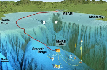
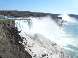
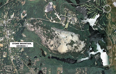
> NIAGRA FALLS WEST - my brother once told me the continental shelf dropped off a few hundred feet from the shore of seabright beach in santa cruz, which tended to keep me close to shore (see photo above - note: while i am generally a land mammal; my sister used to swim out to boats!) and if you look at SECTION X in the photo above (click here), this underwater ravine was probably formed through water erosion from the ancient SAN LORENZO RIVER (and/or NEARY LAGOON, SANTA CRUZ SMALL CRAFT HARBOR, TWIN LAKES, SCHWAN LAKE, CORCORAN LAGOON and MORAN LAKE etc, which were once rivers and/or sloughs, depending upon sea levels between ice ages) - SECTION Y was likely formed by the primordial PAJARO RIVER, ELKHORN SLOUGH, MORO COJO SLOUGH and the SALINAS RIVER etc, which once joined at this point as well -- in fact; during times of rapid glacial melting, the entire north american continent becomes an occasional 'giant river bed' of sorts, and these occasional deluges have left much evidence of this extreme water erosion -- good examples of this glacier-related erosion are: STONE MOUNTAIN in georgia, and the GRAND CANYON in arizona - which in the past has likely been filled to the brim and/or spilled over many times over -- due to this process, the area depicted in the photo above likely looked alot like NIAGRA FALLS in the canadian province of ontario (see photos below)...