GLACIAL THAW EROSION THEORY:
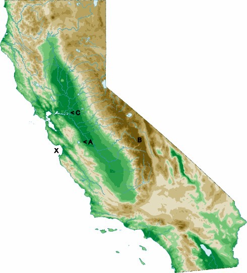
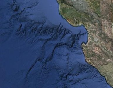
If you look closely at this California map (which I accessed from http://www.california-map.org/topo-map.htm) -- you can see the letters A B C & X -- QUESTIONS: At the end of each ice age and/or glacial epoch (of which there have been several) -- did massive ice melt in these upper altitudes of the Sierra Nevada range [where the most expansive square footage of high altitude landscape exists (see B)] and cause torrents of water to exit the upper altitudes; therefore flooding the Central Valley basin? -- And while a majority of this water exited -- and still exits -- through the California Delta region (see C) because of the relative placement of the Anderson Reservoir/Pacheco Pass region (see A) did this annual glacial water erosion take out an entire section of mountain range and create what is now known as Pacheco Pass? (see A) along with create what is now but a remnant from this watery era in San Luis Reservoir? -- [now an artificial water storage area which would normally drain into the Pacific Ocean through the Delta and San Francisco Bay regions (see C) kept roughly 500+ feet above sea level for water storage and hydroelectric energy generation] > see also: ALABAMA HILLS @ http://en.wikipedia.org/wiki/Alabama_Hills -- Are the Alabama Hills an obvious result of massive gravitationally-influenced glacial water erosion at the base of Mount Whitney in the Western Sierra foothils; the highest point in North America? -- And finally; did this water help carve the ancient rivers which lie on the bottom of what is now modern day Monterey Bay??? (see X and photo below)
28 jan 2011